
Flooding is a natural part of life in the lower Snoqualmie Valley area of Western Washington. Historically, when seasonal rains would begin, many residents, land managers, and farmers would use as many data resources as they could to know if and when the Snoqualmie River would leave the banks and cover roads and farm fields. They need to prepare ahead of time by moving equipment and livestock to high ground.
Originally, there was only one US Geological Survey gauge transmitting water level data during a flooding event along the 30 miles of the river. However, community members in this area knew of multiple places where water would spill out from the banks of the river.
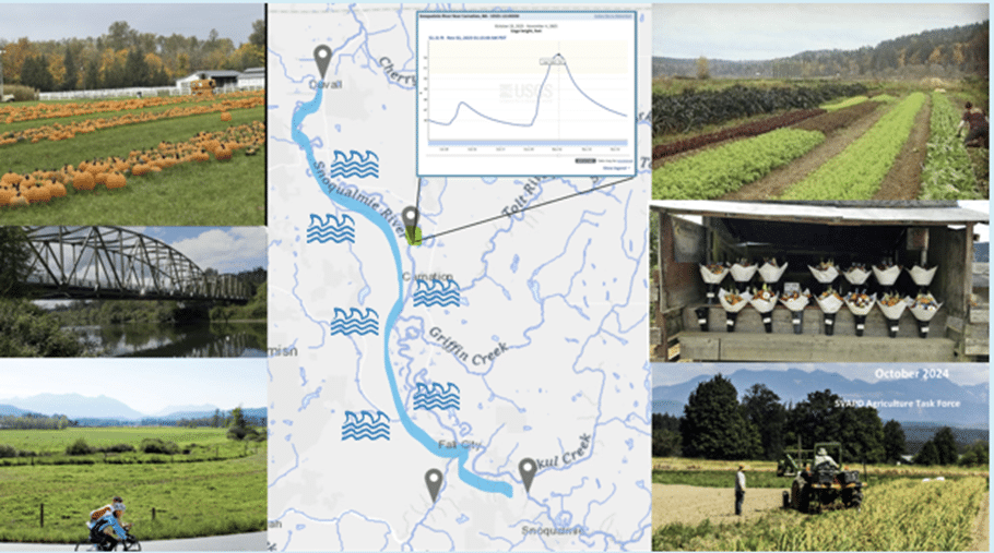
We have a lot of caring, clever, ambitious people in the valley. Around 2018, this project was coordinated to monitor water levels better near these roads. Community members set out to survey road levels, engineer ultrasonic sensing devices, build gauge structures, and program a LoRaWAN radio network. Snoqualmie Valley Preservation Alliance, in coordination with Geary Eppley and with funding from a King County Flood Control District grant, began creating a flood-monitoring network to enhance visibility of flooding up and down the river.
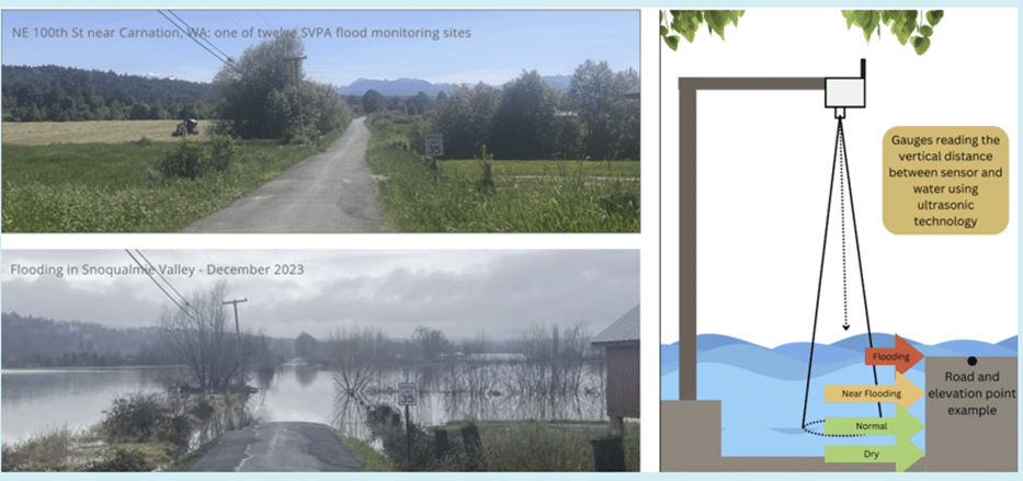
This picture (above left) is the type of scenario that many residents and land managers were encountering. They didn’t know how deep the water was, if it was rising or falling, and if there was even water at all along a road if they lived offsite from where they worked and needed to commute in.
The solution (above right) was to create a monitoring system that detected water height at different levels: Dry, Normal, Near Flooding, and Flooding. All relative to the nearby roads.
Today, we have expanded the network to cover 14 unique flood-prone sites to monitor those water levels. They transmit data every 15 minutes, 24 hours a day. We also import USGS gauge data to this map as well. Our Forecast page brings in flooding prediction data upstream.
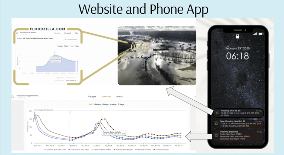
This data can be found on the Floodzilla website or in our phone app, where you can sign up for specific site-flooding and flood-prediction alerts via text or push notifications. The Floodzilla Gauge Network is free for the public to use.
Regina Fletcher is the Floodzilla Gauge Network Program Manager at the Snoqualmie Valley Preservation Alliance, a community-based, 501(c)(3) nonprofit organization committed to protecting and enhancing the lives, livelihoods, lands, and waters of the beautiful Snoqualmie River Valley.
Scott Ensign
@rgmfletcher Thanks for sharing news about this incredible monitoring program! I found more information on your webpage (https://svpa.us/floodzilla-gauge-network/), but I didn’t see anything about the technology you are using. Do you have more details about the sensors, data loggers, radios, and code you have built for Floodzilla?
Regina Fletcher
@ensign Thanks for the great question. So prior to 2018, SVPA was building its own sensors. After 2018 the program began using Senix Brand ultrasonic sensors on a private MTS system, reading to configured Multitech Brand gateways. In 2024 the Senix company no longer sold devices with our LoRaWAN configuration, so we began the process of configuring our network to Public LoRaWAN. We are still in the process, with a portion of our network completed.
We began ordering Milesight brand sensors (EM500-UDL Ultrasonic Distance/Level Sensor) and Milesight gateways ( UG63 Mini and UG65) and integrating them into our network. Our monitoring sites required a 30 foot range detection. As we began to test out this new brand, we discovered that the “sensing cone area” below the sensor is a 60 degree angle, providing a wider and wider detection area as the ultrasonic sound bounces back to the sensor. This was not as good of a fit for our agricultural drainage ditches, which can be smaller than the diameter of the sensing cone area. In addition to that, we were curious about trying out radar technology, to help us overcome some missing data points we suspected could either be from temperature fluctuations, or noisy environments.
At the moment, we are hoping to try out radar technology with a company called Vega. Since this is the same brand used for the Open-source River Camera and Altimetry (ORCA). If anyone has experience with using this product (and radar technology) long term, feel free to give us some updates in Sensor Forum: https://www.envirodiy.org/topic/new-sensor-supplier-for-floodzilla-flood-monitoring-network/
Our Network Server is through The Things Stack, and our Application Server is through Microsoft Azure.
You can find info on our open source code on github here: https://github.com/snovalleypa/floodzuki
We began a transition to using a phone app to display the data and push notifications in 2023. Although, our prior SMS text message system through a subscription to Plivo sends the same info as the push notifications for a small cost.
A big goal in the near future is to provide language translations and outreach to the local Hmong farming community. We provide Spanish translations for our website but would like to keep improving our service to the local community.