I originally learned of using side scan sonar/side imaging/fish sonar from a kayak fisherman tinkering around with a Side Scan Sonar/fish sonar device.
I found more academic literature as I dived deeper:
Assessment of Deadhead Logs and large Woody Debris using Side Scan Sonar and Field Surveys
A Novel Approach to Surveying Sturgeon Using Side-Scan Sonar and Occupancy Modeling
- in Marine and Coastal Fisheries: Dynamics, Management, and Ecosystem Science
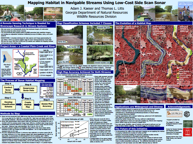
My header image as well as most of the inspiration for this post is from Adam J. Kaeser and Thom L. Litts, An Illustrated Guide to Low-cost, Side Scan Sonar Habitat Mapping in Marine and Coastal Fisheries: Dynamics, Management, and Ecosystem Science
What I want to do
Information on benthic substrate is often gathered through methods with fast spatiotemporal decay. One might sample by transect in the summer, then floods & hurricanes change the nature of substrate by winter.
I want to explore using a Side Scan Sonar to map changing substrates over time to track changes in land use/real estate development patterns upstream or possibly find some relationship between dam removal and sediment transport downstream.
I would like to eventually make a lower cost tool. And given that one of my initial sources has already done some [tinkering around with side imaging](http://dizzybigfish.co.uk/kayak-mods-pimp-my-yak/side-imaging-sonar-on-a-kayak/), this may be more than a moonshot.
Why I’m interested
Mapping information tends to stop at a body of water.
Gathering information and data on what is under the water requires high cost or high time costs to gather transects and extrapolate. High resolution data like topobathy and bathymetric lidar is obtained through expensive, time consuming methods–large flight planning crews, flight crews, airplanes, etc.
The work by Kaeser & Litts has been presented & workshopped numerous times since 2010 featuring the need for a remote sensing technique needed for riverscape research in stream systems.
One current project using Side Scan Sonar for substrate mapping is the Chipola River Applied Habitat Benthic Mapping Project in northwest Florida led by Southeast Aquatics Resource Partnership.
The Chipola River Applied Habitat Mapping Project with investigators, Jennifer Bock and Beth Stys, was featured earlier in 2014 in the Fisheries and Information Technology section of the American Fisheries Society as well: Landscape Level In-Stream Habitat Mapping Using Side Scan Sonar.
Low-cost benthic habitat mapping is highly important and cheaper than flying a lidar mission. However, devices for side scan sonar are still in the four-figure range ($2000+).
My attempt and results
I am identifying needs and user scenarios for a lower cost side scan sonar.
I will keep watching for an after market device, troubleshooting guide, or teardown review to make an inventory the components in the device. From there, I can identify potential sellers of the components and see where I can view existing software or papers covering the software used to produce the images.
Questions and next steps
1. Read through the Sonar Imagery Geoprocessing Workbook.
2. Gather resources, equipment, information, code, etc.
3. Gather users & collaborators as there has been mention of a need for repurposing fish sonar.
4. Learn more from past forums covering side scan sonar
All images from Adam J. Kaeser and Thom L. Litts, An Illustrated Guide to Low-cost,
Side Scan Sonar Habitat Mapping
**Originally posted as a Research Note on Public Lab.org**